Plan release information
The Gingin surface water allocation plan was released in April 2011.
Supporting documents for the plan are also available:
- Gingin surface water allocation plan: Methods report
- Gingin surface water allocation plan: Statement of response
The plan describes how we will manage the plan area’s fully allocated water resources and how we will monitor, measure and evaluate the objectives of the plan.
The methods report describes how the department decided on the annual allocation limits for each of the surface water resources.
The statement of response summarises our response to comments and questions we received on the Gingin surface water allocation plan: draft for public comment.
The Gingin groundwater and surface water allocation plans: 2024 evaluation statement was released in June 2024.
The evaluation statement is the second published evaluation of the 2011 Gingin surface water allocation plan and the first for the 2015 Gingin groundwater allocation plan. The statement evaluated the performance of both allocation plans since their release and found ongoing risks to groundwater and surface water resources in the southern part of the region where climate change and abstraction has led to long term declines in groundwater levels and streamflow. The evaluation showed we needed to put updated management arrangements in place to help ensure the sustainability of these groundwater and surface water resources.
The updated management arrangements in the evaluation statement will be considered in conjunction with the existing management arrangements for the area in the Gingin groundwater and Gingin surface water allocation plans.
The updated management arrangements in the evaluation statement will be considered in conjunction with the existing management arrangements for the area in the Gingin groundwater and Gingin surface water allocation plans.
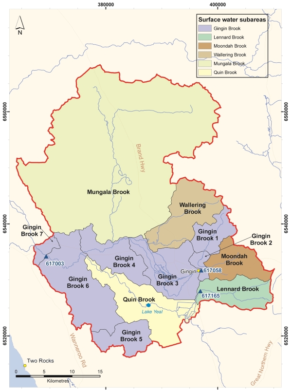
Surface water plan area
The Gingin surface water plan area is about 90 kilometres north of Perth and covers 1,430 km2.
Most of the area is in the Shire of Gingin, except for a small portion in the south-east, which is in the Shire of Chittering.
Surface water resources
The plan applies to Lennard, Moondah, Gingin, Wallering, Mungala and Quin brooks and their tributaries.
For management purposes, the plan area is divided into 12 resources with Gingin Brook divided into seven resources.
Water allocation planning for Gingin
The allocation limits, licensing rules and monitoring programs in the 2011 Gingin surface water allocation plan and the 2015 Gingin groundwater allocation plan, together with the updated management arrangements in the 2024 evaluation statement, guide the management of water resources to support water users and the region’s unique waterway and wetland ecosystems.
This management of water resources reduces the likelihood of:
- decreasing reliability of current licensed entitlements
- further decline in groundwater levels and pressure heads
- decreasing dry season baseflows in streams
- damage and loss of important groundwater-dependent ecosystems
- the seawater interface moving inland, making groundwater saline.
The updated management arrangements in the Gingin groundwater and surface water allocation plans: 2024 evaluation statement are an important interim step while a new combined Gingin water allocation plan is developed. The new combined allocation plan will capture the complex groundwater/surface water interactions throughout the Gingin area as part of managing the ongoing impacts of climate change and abstraction.
Publications
Gingin groundwater and surface water allocation plans: 2024 evaluation statement
Gingin surface water allocation plan
Gingin surface water allocation plan: Statement of response
Gingin surface water allocation plan: Methods report
Gingin surface water allocation plan: Evaluation statement 2011–2012
Groundwater-surface water interaction along Gingin Brook Western Australia
Capacity of water resources in the Mid West to meet mining and industrial growth