Plan release information
The Gingin groundwater allocation plan was released in March 2015.
Supporting documents for the plan are also available:
- Gingin groundwater allocation plan: Statement of response
- Gingin groundwater allocation plan: Methods report
The statement of response summarises our response to comments and questions we received on the Gingin groundwater allocation plan: for public comment which was released in 2013.
The plan includes allocation limits, which outline how much water is available in the Gingin groundwater plan area. It describes how the Department of Water and Environmental Regulation will allocate and manage water resources and how we will monitor, measure and evaluate the objectives of the plan.
The Gingin groundwater and surface water allocation plans: 2024 evaluation statement was released in June 2024.
The evaluation statement is the first published evaluation of the 2015 Gingin groundwater allocation plan and the second for the 2011 Gingin surface water allocation plan. The statement evaluated the performance of both allocation plans since their release and found ongoing risks to groundwater and surface water resources in the southern part of the region where climate change and abstraction has led to long term declines in groundwater levels and streamflow. The evaluation showed we needed to put updated management arrangements in place to help ensure the sustainability of these groundwater and surface water resources.
The updated management arrangements in the evaluation statement will be considered in conjunction with the existing management arrangements for the area in the Gingin groundwater and Gingin surface water allocation plans.
Groundwater plan area
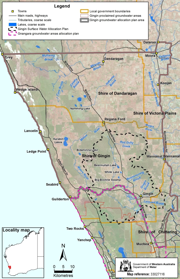
The Gingin groundwater plan area is about 90 km north of Perth and extends over 6,000 km2.
The plan area covers most of the Gingin groundwater area, in the south of the Northern Perth Basin. It extends from Grey and Moora in the north, to Guilderton and Bindoon in the south. It includes the towns of Lancelin, Seabird, Guilderton, Dandaragan, Moora, Bindoon and Gingin.
Along with the Jurien and Arrowsmith groundwater areas, Gingin is part of the Northern Perth Basin.
Groundwater resources
The plan area includes nine main aquifers — Surficial, Superficial, Mirrabooka, Cattamarra, Lesueur Leederville, Leederville–Parmelia, Yarragadee and Fractured Rock aquifers.
For management purposes, the area is divided into 25 subareas. Together with the aquifers, it covers a total of 35 resources (a portion of an aquifer within a subarea). Subareas south of the Gingin Brook are managed under the Gnangara groundwater areas allocation plan.
Water allocation planning for Gingin
The allocation limits, licensing rules and monitoring programs in the 2015 Gingin groundwater allocation plan and 2011 Gingin surface water allocation plan, together with the updated management arrangements in the 2024 evaluation statement, guide the management of water resources to support water users and the region’s unique waterway and wetland ecosystems.
This management of water resources reduces the likelihood of:
- decreasing reliability of current licensed entitlements
- further decline in groundwater levels and pressure heads
- decreasing dry season baseflows in streams
- damage and loss of important groundwater-dependent ecosystems
- seawater moving inland, making groundwater saline.
The updated management arrangements in the Gingin groundwater and surface water allocation plans: 2024 evaluation statement are an important interim step while a new combined Gingin water allocation plan is developed. The new combined allocation plan will capture the complex groundwater/surface water interactions throughout the Gingin area as part of managing the ongoing impacts of climate change and abstraction.
Publications
Gingin groundwater and surface water allocation plans: 2024 evaluation statement
Gingin groundwater allocation plan
Gingin groundwater allocation plan: Methods report
Gingin groundwater allocation plan: Statement of response
Gingin groundwater allocation plan: for public comment
Groundwater-surface water interaction along Gingin Brook
Environmental considerations for groundwater management of the Northern Perth Basin
Capacity of water resources in the Mid West to meet mining and industrial growth
Northern Gnangara airborne electromagnetic survey
Managing groundwater in the Gingin area fact sheet
Groundwater investigation program in Western Australia (2005 to 2020)
Hydrogeology of the Swan Coastal Plain between Cervantes and Leeman
Gingin groundwater allocation plan newsletter - April 2011
Gingin groundwater allocation plan newsletter - June 2011
Gingin groundwater allocation plan newsletter - September 2011