Plan release information
The Ord surface water allocation plan was released in October 2013.
Supporting documents for the plan are also available:
- Ord surface water allocation plan: Statement of response
- Ord surface water allocation plan: Methods report
The plan replaces the Ord River water management plan and sets a new approach for managing water allocation and licensing in the area.
We periodically release updates on progress in meeting the plan's objectives. The first Ord surface water allocation plan: Evaluation statement 2013–2017 is available.
Water allocation planning in the Ord River
We have prepared the Ord surface water allocation plan to manage the growing water demands on the Ord River. The plan will be used to manage competing demands for water between hydroelectricity generation and the expanding irrigation industry, while maintaining sufficient flow into the lower Ord River to protect the riverine environment.
The Ord plan:
- sets annual allocation limits for each of the five subareas in the Ord plan area totalling 905 gigalitres per year
- establishes water releases rules for Lake Argyle to maintain the security of irrigation licences in the Main Ord subarea
- explains the process by which we license water use and adjust water licences as demand from irrigation and hydroelectricity changes over time
- sets an environmental water provision, measured at the Tarrara Bar gauging station, to maintain the existing post-dam environmental values of the lower Ord River
- recognises the importance of low-flow periods to the Miriuwung Gajerrong people.
Plan area
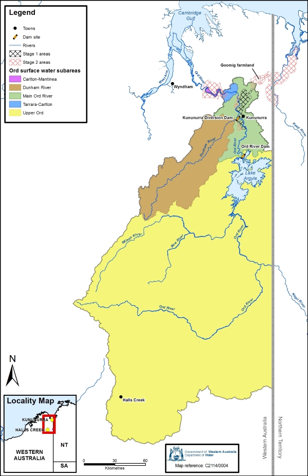
At 650 kilometres long, the Ord River in the east Kimberley is one of the state's major river systems and the Ord River Basin drains an area of 55,100 km2. It includes lakes Argyle and the town of Kununurra.
The plan covers the Western Australian part of the Ord River catchment – specifically the Ord River and Tributaries surface water area and the Ord River Irrigation District.
Water resources
The plan covers the broader Ord River catchment, encompassing the Ord and Dunham rivers and tributaries. It includes the surface water resources of the Ord River catchment to its tidal limit, including run-off from the Northern Territory that contributes to the Ord River.
For management purposes, the plan area is divided into five subareas – Upper Ord, Main Ord, Tarrara-Carlton, Carlton-Mantinea and Dunham River.
Publications
Ord surface water allocation plan
Ord surface water allocation plan: Statement of response
Ord surface water allocation plan: Methods report
Ord surface water allocation plan: for public comment
Ord surface water allocation plan: Evaluation statement 2013–2017
Managing water from the Ord River brochure
Ord River water management plan
Lower Ord River environmental water provisions monitoring program and management framework


