South West Australia is experiencing a drying climate and is a hotspot for global climate change. There are competing demands for groundwater resources right across the Swan Coastal Plain and this is only likely to increase into the future. A robust understanding of groundwater recharge and recharge processes is important if we are to manage these groundwater resources effectively.
Funded by the State Groundwater Investigation Program, the Recharge Estimation Collaboration project (the project) will monitor and analyse recharge processes to determine how climate and land-cover change can impact recharge. We will use project findings to better understand how to develop tools and models to guide water resource management.
What we did during the investigation
The project has two major themes:
- Monitoring to estimate recharge on the Swan Coastal Plain
- Testing, development and application of recharge modelling methods.
Theme 1 was led by UWA’s School of Engineering. It involved the development of a strategic field program to monitor recharge at key locations. These locations included a range of land-cover types, such as banksia woodland, pasture, irrigated horticulture, and pine plantations. The monitoring setup is the most comprehensive for estimating recharge ever developed for Australia. The setup relies on multiple observation packages to derive variables and parameters used, independently or in combination, to understand recharge dynamics and to estimate recharge fluxes.
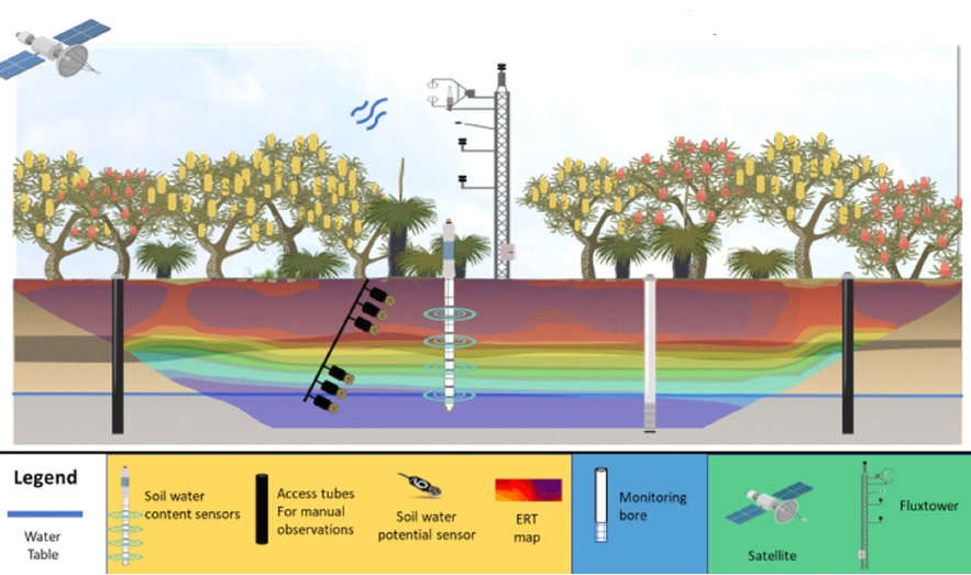
Seven locations have been instrumented with soil-sensing devices varying from permanent electromagnetic sensors for soil–water content and soil–water potential, to manually operated neutron moisture probes and electrical resistivity tomography transects. High-quality soil cores (by sonic drilling) were also collected at these locations. Monitoring data are sent directly to cloud storage drives to be downloaded and analysed by the team in near real-time, which form a comprehensive database.
An example of the typical instrumentation at each site is shown in Figure 1. The team of researchers is analysing this data, in conjunction with existing monitoring data, to assist in recharge estimation, process understanding, and defining how climate change and recharge interact.
Theme 2 was led by CSIRO Land and Water in Perth, who have worked closely with the Institute of Geological and Nuclear Sciences Limited (GNS) in New Zealand. This component looks at a range of methods we can use to incorporate recharge into our groundwater models – and how complex a recharge estimation method in a groundwater model needs to be to produce reliable predictions.
Key findings and how we are using the information
Key findings of the investigation include:
- There has been substantial decline in groundwater recharge over the past 50 years due to fewer winter storms. This decline in recharge is disproportionately larger than annual rainfall declines. Measurements of recharge since the 1960s show near-linear reductions in potential recharge of 50 per cent, in response to a 20 per cent reduction in rainfall. For the best-represented land cover in the dataset (Banksia woodland), the reduction in potential recharge was closer to 70 per cent.
- The water table fluctuation method can be used to estimate recharge rates but is subject to significant uncertainties. The method is generally more robust for deeper groundwater systems with monthly or greater sampling frequency. Uncertainties in this method become greater in areas of shallow water table and high recharge rates.
- A suite of modelling methods ranging from simple to complex can be used to estimate recharge. The everyday practice of spatially lumping recharge model parameters can induce bias in recharge predictions, while predictions of hydraulic head appeared insensitive to this bias. Where new climate stresses were introduced, there was no clear, or systematically better, simple model performance across all models tested.
- Defining the prior parameter probability distribution for simple models proved to be challenging. These parameters were difficult to relate directly to field tests. Priors derived in this study will be useful in informing future modelling efforts.
- Monitoring data collected by UWA will assist in constraining recharge estimates for all modelling methods.
A major recommendation from the project was to implement long-term monitoring using consistent methodologies and assessing different components of the climate variables. This will enable the characterisation of recharge responses to climate change, and overcome existing interpretation challenges created by inconsistent sites, methods and durations of recharge estimation. This has led to the establishment of the Recharge in a Changing Climate project, which has allowed UWA researchers to extend the monitoring dataset, and to develop a more complete understanding of the response of recharge to rainfall declines and other climatic variables.
The monitoring and modelling efforts will be used to develop future versions of the Perth Region Aquifer Modelling System (PRAMS) and other coastal plain groundwater models, making recharge estimates more reliable, enhancing our ability to make better predictions, and therefore, enabling us to make more informed decisions.
Where to get more details
You can ask for copies of the internal technical reports for this investigation by contacting groundwater.info@dwer.wa.gov.au.
Go to our Water Information Reporting portal to access data from the monitoring sites installed during the investigation.